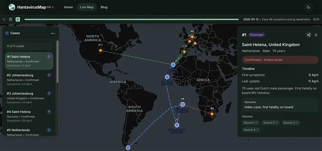
Reviewed Tracker 2026

Hantavirus Map 2026

Open a reviewed, source-linked hantavirus map of case records, monitoring signals, MV Hondius route context, and USA hotspots.

Current situation

ECDC case classification for MV Hondius, with reviewed map signals shown separately

ECDC update: 24 May 2026

10

Confirmed

2

Probable

0

Suspected

3

Deaths

Official source: ECDC (24 May 2026)Page generated: June 9, 2026 at 08:05 PM

RiskRadar preview
Expand map
Global hantavirus outbreak map showing confirmed cases and monitoring zones
Live mapSource-linked

Interactive Global Case Tracker

View case markers, route links, timeline events, and source URLs.

Open map
ConfirmedMonitoringCruise routeClick markers

10

Confirmed

2

Probable

3

Deaths

Reviewed signals

Public entries are checked before display.

Source-linked

Map dots keep source and date context visible.

Signal tracker

Not an official global case registry.

Feed checked

June 9, 2026 at 08:05 PM

Dashboard view

Official Outbreak and Map Signal Statistics

The MV Hondius case counts use ECDC's official outbreak classification. The map signal counts remain a reviewed public-awareness layer.

Reviewed feed generated June 9, 2026 at 08:05 PM

12

ECDC total cases

9 confirmed, 2 probable; inconclusive case removed

3

Official deaths

Reported in the ECDC outbreak update

19

Approved map records

Reviewed public signals visible on the map

7

Reviewed countries

Countries represented in approved map records

Case Status Distribution

Case status

Cases by Country

Top regions

Reviewed feed

Latest Source-Linked Hantavirus Map Signals

The hantavirus map live feed highlights recently approved public signals. Each item is tied to a location, review status, and source context before it appears on the hantavirus map.

Explore these signals on the hantavirus map
Signal 1Confirmed

Victoria, Canada

5/16/2026Andes strainSource: PHAC/ECDC/AP

Canadian passenger from Yukon. PHAC reported National Microbiology Laboratory confirmation of Andes hantavirus on 16 May 2026; public reporting placed the patient in hospital isolation in Victoria, British Columbia, with mild symptoms and a partner who tested negative.

View on map
Signal 2Confirmed

Paris, France

5/12/2026Andes strainSource: Wikipedia/ECDC/WHO

French female passenger. Developed symptoms during repatriation. In ICU in Paris hospital. Status: Serious.

View on map
Signal 3Confirmed

Madrid, Spain

5/11/2026Andes strainSource: Wikipedia/ECDC/WHO

Spanish passenger. Hospitalized in Madrid.

View on map
Signal 4Inconclusive

Nebraska, United States

5/10/2026Andes strainSource: Wikipedia/ECDC/WHO

American passenger. Inconclusive test result. Under quarantine in Nebraska. Status: Healthy.

View on map
Signal 5Probable

Tristan da Cunha, United Kingdom

5/3/2026Andes strainSource: Wikipedia/ECDC/WHO

British male passenger. Hospitalized in Tristan da Cunha. Status: Stable.

View on map

Verification model

How We Verify Hantavirus Map Signals

HantavirusMap.life is built for public situational awareness. Each hantavirus map signal is organized by source quality, reviewed before public display, and kept separate from medical advice.

Source quality before map visibility
01

Source collection

We track official health sources, public outbreak updates, ProMED-style reports, and credible news leads tied to specific locations.

02

Review before display

Official sources can be approved faster; community or news leads stay out of the public map until they pass review.

03

Map-ready context

Approved records include location, status, source name, date, and supporting notes so users can inspect the signal instead of relying on a bare dot.

Status labels: Confirmed means a source-linked case or official report is available. Monitoring means a location is being watched for signal context, not that a diagnosis has been confirmed.

Why this tracker

Why Use Our Hantavirus Map Tracker

A clear hantavirus map tracker helps people move from scattered public reports to a structured view of locations, sources, and status labels.

Fast orientation

The map puts recent case records, monitoring signals, and route context in one place so users can quickly understand what is being tracked.

Map-first access

The tracker is designed for mobile and desktop visitors who want to open the hantavirus map, scan locations, and inspect source-linked details without signing in.

Source-aware review

Community chatter and news leads are treated cautiously. Public map entries are separated by status and supported by source context where available.

How to Use the Live Hantavirus Map

Use the hantavirus map to scan locations, compare status labels, and follow source-linked notes. Whether you are checking the hantavirus map usa or the hantavirus map global view, start with the same three steps:

1

Zoom and Filter

Open the hantavirus map display and filter by status, passenger or crew context, and route layers where available.

2

Check status and sources

Red dots indicate confirmed hantavirus map records, while yellow dots identify monitoring locations. Open a marker to review source and case notes.

3

Use it for awareness

Use this hantavirus map as situational awareness, then consult official health guidance or medical professionals for personal decisions.

Open the Live Hantavirus Map
How to use the Hantavirus Map RiskRadar - Zoom, filter, and analyze risk zones
Map controlsStatus / Route / Region
CasesRoutesSources

Behind the Hantavirusmap: Our Data Methodology

Every public dot on this hantavirus map should have context: where it came from, what status it carries, and why it is visible. Official sources carry the most weight, while news and community leads are handled cautiously. The goal of the hantavirus map tracker is to make public signals easier to inspect, not to replace official health guidance.

WHO

WHO

Official health notices

CDC

CDC

US public health guidance

EU

ECDC

European surveillance

PM

ProMED

Emerging disease monitor

N

NewsAPI / Google News

Filtered public reports

Hantavirus Health Guide

Understanding hantavirus symptoms and prevention strategies is your first line of defense. Explore our comprehensive health guides to protect yourself and your loved ones during this outbreak.

Beyond the Hantavirus Map: Education & Resources

A visual hantavirus map is only one part of the safety solution; proper education is the other. Visit our dedicated blog sections to learn exactly what is hantavirus and discover crucial hantavirus symptoms to watch out for. Understanding these medical details perfectly complements the geographic data you see on the hantavirus map live, empowering you to take the proper preventive measures during this hantavirus outbreak.

Hantavirus Map 2026 FAQ